 RunCity
Muraste on foot: a self-guided walking route
This route takes you past 8 of Muraste's best-known sights, including Tilgu cliffs viewpoint, Tilgu harbour, Tilgu beach and more. It is about 9 km on foot, roughly 2.5 hours at an easy pace with short stops. Follow the list on your own, or play it as a free GPS checkpoint game with RunCity and race the clock on the Muraste leaderboard.
- 8Stops
- about 9 kmDistance
- 2.5 hoursWalking
- about 70 minRunning


Muraste is a village on the coast west of Tallinn, on top of the North Estonian Klint, the limestone cliff that runs along the Gulf of Finland. This route follows the cliff and the shore below it in about 8 km. It starts at the Meriküla stair tower, a rust-red tower with a lift that takes you down the cliff to the sea, then follows the path at the foot of the cliff through the Muraste nature reserve, past layered sandstone walls and pillars the waves have cut out of the rock.
The shore path leads east to the beach and the small harbour at Tilgu, where a café sits on the quay, and up to a viewpoint on the cliff edge. Back on top, the route crosses the village to Muraste Manor, a manor house with a tower in its old park, and ends at the bonus point, the Suurupi lower lighthouse, a white wooden pyramid from 1859 and the only wooden lighthouse still working in Estonia.
The stops
-

Tilgu cliffs viewpoint Photo
The cliff edge and the sea below.
-

-

-
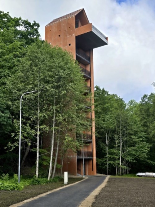
Meriküla stair tower Photo
The whole tower from the path at its foot.
Photo: Private photo · used with permission
-

Sandstone pillars on the shore Photo
The sandstone pillars at the foot of the cliff.
-

Sandstone cliff below Muraste Photo
The layered sandstone cliff seen from the shore.
-

-

Suurupi wooden lighthouse Bonus
Estonia's only working wooden lighthouse, a white wooden pyramid from 1859.


Getting around
Public transport is run by IIL. The app to have: Pilet.ee. If you take several rides in a day, a day ticket covers them all. You can also tap a contactless bank card on the reader to pay a single fare. Fares and tickets
Leaderboard
Questions
Can you see Muraste on foot in one day?
Yes. The 8 stops on this route add up to about 9 km, roughly 2.5 hours at an easy pace with short stops.
Is this self-guided walking tour free?
Yes. The route and map on this page are free, and the RunCity game for Muraste is free during launch.
How does the RunCity game work in Muraste?
Open Muraste in RunCity, walk to a stop and tap Validate: your phone's GPS confirms you are there. Some stops also ask for a photo. Timed runs go on the Muraste leaderboard.
Where does the route start?
This page suggests starting at Tilgu cliffs viewpoint and finishing at Suurupi wooden lighthouse. In the game you can take the stops in any order.
What's the best public transport app in Muraste?
Pilet.ee, the app for IIL.